![biarri-networks-logo.png]](https://fondhelp.biarrinetworks.com/hs-fs/hubfs/biarri-networks-logo.png?height=40&name=biarri-networks-logo.png)
Path preferencing lets you tell FOND which routes to prefer or avoid when it routes cable through your candidate network. Use it to steer cable onto the routes you’d choose, for example one side of the road rather than the other, or away from a busy road that’s hard to get permits for.
Path preferencing is available in Fiber Planner and Fiber Design projects.
Preference levels
Every underground path and aerial span has one of three preferences:
| Preference | What FOND does | CostFactor |
|---|---|---|
| Neutral (default) | Treats the path normally, with no bias for or against it | 1 |
| Prefer | Favors the path over neutral ones when routing cable | 0.25 |
| Avoid | Uses the path only when there’s no reasonable alternative | 10 |
Behind the scenes, a preference is stored as a CostFactor on the path. A preferred path looks a quarter as costly to FOND, and an avoided path ten times as costly. FOND looks for the lowest-cost design, so it leans towards preferred paths and away from avoided ones.
FOND can still use an avoided path if there’s no reasonable alternative, and it won’t use a preferred path if it doesn’t help. To stop FOND using a path at all, delete it from your input data instead.
Set the preference for one path or span
(Fiber Planner and Fiber Design)
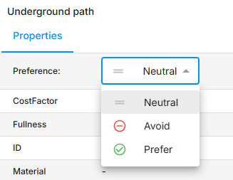
- Click an underground path or aerial span on the map. Its details open in the properties panel.
- Choose Neutral, Avoid or Prefer from the Preference list.
This is the only way to set a preference on aerial spans. You need edit access to the project to change preferences.
Use the Path preferences tool
(Fiber Design)
When FOND generates your underground path and points during data preparation, it sets preferences for you, based on the layout you chose in your design preferences:
- Single-sided: FOND prefers the path on one side of each road, so cable tends to run along that side.
- Dual-sided: FOND leaves both sides of the road neutral and sets road crossings to avoid, so cable only crosses the road when it needs to.
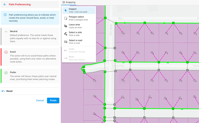
You can review and adjust these preferences with the Path preferences tool.
The Path preferences tool lets you set preferences for many paths at once: a whole side of a road, both sides separately, or everything inside an area you draw.
Open the tool
In the Input data step, choose Refine › Modify data › Path preferences.
On the map, underground paths are colored by preference: green for Prefer, red for Avoid and grey for Neutral. Road crossings show as thinner lines.
Select paths
| Tool | How to use it |
|---|---|
| Inspect (default) | Click a single path. Shift-click to add a path to your selection, or to remove it. |
| Polygon select | Click to place corners, then double-click to close the shape |
| Lasso area | Click and drag a freehand shape |
| Select a side | Click a path to select every path on that side of the road |
| Select a road | Click a road to select both sides at once, so you can set each side separately |
Set the preference
When you select paths, a Preferencing options panel appears. It shows how many paths and crossings you’ve selected, and their current preferences.
- Choose Neutral, Avoid or Prefer.
- To change any selected road crossings too, tick Include crossings. Otherwise they’re left as they are.
- Click Apply.
When you use Select a road, you can set a different preference for each side, labelled by direction (for example, North side and South side). If the road has crossings, choose which side’s preference the crossings should take. A side you leave blank isn’t changed.
After you click Apply, the selection clears and the same tool stays active, so you can move straight on to the next road.
Save your changes
Use Undo and Redo as you go, or Reset to go back to how things were when you opened the tool.
When you’re done, click Finish to save.
Underground points update automatically to match their paths. Each point takes the preference shared by most of the paths connected to it. If there’s a tie, or no paths are connected, it’s set to Neutral.
Upload preferences with your own data
(Fiber Planner and Fiber Design)
To set preferences for a large number of paths, you can set them in a GIS tool and upload them:
- If your paths came from Area Select, export them from FOND first. See Export a project.
- Add a decimal (float or real) field named CostFactor to your underground path or aerial span layer.
- Set CostFactor to 1 for Neutral, 0.25 for Prefer, or 10 for Avoid. It can’t be 0.
- Upload the layer.
In Fiber Design projects, add a CostFactor to your underground points too, usually matching the paths connected to them. The Path preferences tool keeps points in step with their paths automatically, but uploaded data doesn’t.
If a path has a CostFactor other than 1, 0.25 or 10, the properties panel shows the number itself instead of a preference.