![biarri-networks-logo.png]](https://fondhelp.biarrinetworks.com/hs-fs/hubfs/biarri-networks-logo.png?height=40&name=biarri-networks-logo.png)
Streets are lines (LineStrings) that follow the centerline of each road. FOND uses them as a framework for generating other layers of your candidate network.
Streets are used in Fiber Planner, Fiber Design and Power Design projects.
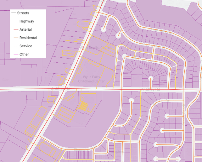
How does FOND use streets?
| Use | Fiber Planner | Fiber Design | Power Design |
|---|---|---|---|
| Become the underground path | ✓ | — | — |
| Generate aerial spans and poles with Area Select | ✓ | ✓ | — |
| Generate dual-sided underground path and points | — | ✓ | ✓ |
| Help detect problematic parcels | — | ✓ | ✓ |
| Help generate clean service area boundaries | — | ✓ | — |
In Fiber Planner, street centerlines become your underground path, so you edit them as underground path. See Underground path and points.
In design projects, streets are their own layer. FOND uses them to generate other layers, so the quality of your streets directly affects the quality of your underground path and points.
Street types
In design projects, FOND groups streets by road type:
| Type | Typically includes | Why it matters |
|---|---|---|
| Highway | Freeways, motorways and state highways | Larger or state-owned roads can be harder to get permits for |
| Arterial | Major roads carrying traffic between neighborhoods | Can also be harder to get permits for |
| Residential | Local streets in residential areas | Where most networks run |
| Service | Parking aisles, alleyways and access roads | FOND doesn’t generate underground path along these unless you turn on Include service roads. See Generation options. |
| Other | Roads that don’t fit the other types | Worth checking to see what they are |
Use the legend to show or hide each type. This makes it easy to check which streets are service roads, and where your network might run along roads that are harder to get permits for.
What makes good streets?
- There’s a centerline on every road where you want the network to run. In design projects, FOND only generates underground path along roads that have a street centerline.
- Each line follows the center of the road. Inconsistent overlaps with parcels can cause issues in underground path generation.
- Streets are classified correctly, especially service roads, which are left out of generation by default.
- There are no streets where there’s no real road.
| New development area is missing addresses, streets, and parcel definition. FOND does not generate underground path. | 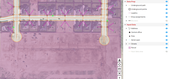 |
| After adding addresses and streets and cleaning parcels, FOND is able to generate a dual sided network with crossings at parcel boundaries. | 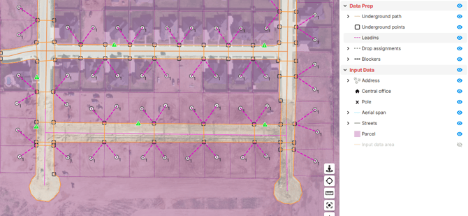 |
Get streets into your project
- Import with Area Select (recommended). FOND’s street data comes from open-source mapping and is already classified by road type. See Import data with Area Select.
- Upload your own. Streets must be lines (LineStrings). If you want FOND to ignore service roads, then you will need ot have a field named Highway with an attribute value of service for those roads. See Input data requirements.
Review your streets
Review your streets before you generate underground path and points. A missing street means missing path, and adding a street is much quicker than drawing the path by hand.
Tips for reviewing:
- Use the satellite map to look for roads with no centerline, especially in new developments and on private roads. See Moving around the map in FOND.
- Check service roads. Decide whether your network needs to run along any of them, such as back alleys that serve homes. If it does, turn on Include service roads before you generate.
- Note highways and arterials. Think ahead about whether you’ll be able to get permits for path along or across them. Review the path generated there especially carefully.
Edit streets
In design projects:
- Choose Input data › Streets › Draw.
- Make your changes:
- Add a street by drawing a line along the center of the road.
- Delete a street by selecting it and deleting it.
- Move a street by selecting it and dragging it.
- Reshape a street by dragging its vertices.
- Save your changes by clicking Finish.
Common edits
| Situation | What to do |
|---|---|
| A road has no centerline, often in a new development or on a private road, because FOND’s data isn’t up to date | Draw in the street, using satellite imagery as a guide |
| A street appears where there’s no real road | Delete it |
| A street doesn’t follow the road | Reshape it by dragging its vertices |