![biarri-networks-logo.png]](https://fondhelp.biarrinetworks.com/hs-fs/hubfs/biarri-networks-logo.png?height=40&name=biarri-networks-logo.png)
Underground path and underground points show FOND every location where it can lay cables or wires and place equipment underground. Together they form the underground part of your candidate network.
- Underground path is a set of lines (LineStrings) showing where cables or wires can run.
- Underground points are points showing where equipment such as hubs, splices, trasformers, and therefore vaults, pits or handholes can go.
Underground path is used in Fiber Planner, Fiber Design and Power Design projects. Underground points are used in design projects only.
How does FOND use underground path and points?
| Fiber Planner | Fiber Design | Power Design | |
|---|---|---|---|
| Underground path | ✓ | ✓ | ✓ |
| Underground points | — | ✓ | ✓ |
| Typical layout | Street centerlines | Dual-sided | Dual-sided |
In Fiber Planner, underground path is usually just the street centerlines. That’s enough for feasibility planning, where FOND needs to know roughly where cables can run.
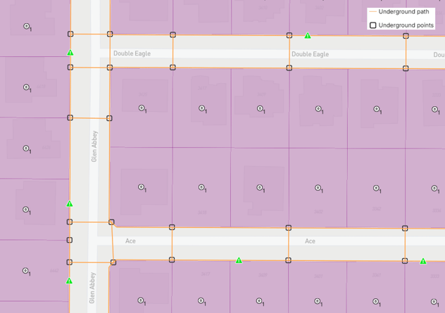
In design projects, FOND uses a dual-sided layout. The path, or running lines, follows the real constructible locations along the right of way on both sides of the street, and includes street crossings. Underground points sit along the path wherever equipment can go.
When FOND generates your design, it places cables or wires and equipment on this candidate network, using only the parts it needs. FOND treats every path in your candidate network as valid, so it may route cables or wires along any of it.
What makes good underground path and points?
These apply to all projects:
- There’s no path where you can’t build, such as across railways or major roads, or anywhere you can’t get permits.
- Underground connections to poles are in suitable places, if your project also uses aerial data.
These apply to design projects:
- Path runs along the right of way, following parcel boundaries, not down the middle of the road.
- There are enough crossings. The design step needs options for where to cross the road, so it can find the best cable or wire route.
- Crossings and points are in constructible locations, for example not in driveways. Use the satellite map to check.
- Crossings cross at a sensible angle.
- Path and points are snapped together, so the network is fully connected.
Get underground path and points into your project
| Method | Fiber Planner | Fiber Design and Power Design |
|---|---|---|
| Generate with the data preparation tools | — | ✓ (recommended) |
| Import with Area Select | ✓ (recommended) | ✓ |
| Upload your own | ✓ | ✓ |
Generate them with the data preparation tools
In design projects, FOND can generate a dual-sided underground path and points from your parcels and streets.
To generate them, ensure that underground path is selected in the settings in the Candidate network section of your Input data step, then click Run data preparation.
When it generates underground path, FOND:
- Places path on both sides of each street, following parcel boundaries where it can
- Places points and crossings at parcel boundaries where it can (mid-street crossings)
- Places points and crossings at street intersections (intersection crossings)
- Adds some extra crossings that don’t end exactly at a parcel boundary, so the design step has enough options for routing cables or wires
Generation options
Before you run data preparation, check the underground path options in the Candidate network settings:
- Include service roads (Fiber Design and Power Design). Service roads include parking aisles, alleyways and similar minor roads. This is off by default, so FOND doesn’t generate path or points along them. Turn it on if your network needs to run along service roads, for example where homes are served from a back alley.
- Path preferences (Fiber Design only). These control path layouts that FOND prefers when routing cables.
Good parcels and streets make good path
Generated underground path is only as good as the parcels and streets it’s based on:
- Parcels: Clean parcels give FOND accurate lot lines to follow and keep the path out of the road. Remove street parcels before you generate. See Parcels.
- Streets: FOND only generates underground path along roads that have a street centerline. Make sure there’s a centerline on every road where you want path.
| New development area is missing addresses, streets, and parcel definition. FOND does not generate underground path. | 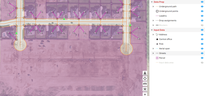 |
| After adding addresses and streets and cleaning parcels, FOND is able to generate a dual sided network with crossings at parcel boundaries. | 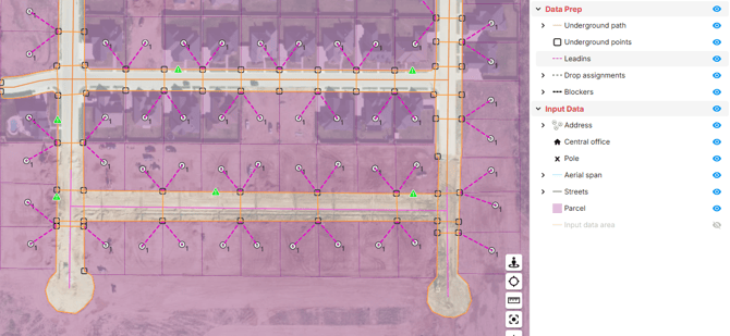 |
Import with Area Select
Area Select imports street centerlines from FOND’s database. In Fiber Planner, these become your underground path. See Import data with Area Select.
Upload your own
If you already have underground path and points, you can upload them instead. Make sure they’re well connected: every path should be snapped to points or other path at its ends, with no gaps. FOND marks disconnected path and points (see below), so check your data in a GIS tool before you upload, or use FOND’s own drawing tools. See Input data requirements.
Review your underground path and points before you design
Always review your underground layout before you run a design. A few minutes of review here saves fixing the design later.
Tips for reviewing
- Remove any path you can’t build on. Delete path that crosses railways or major roads, or anywhere you can’t get permits. Otherwise FOND may route cables or wires along it.
- Check crossings against the satellite map. Look for crossings or points in driveways, and crossings at awkward angles. See Moving around the map in FOND.
- Look for gaps. Make sure there are enough crossings along each street, especially on long blocks.
- Look for red path and points. They aren’t connected properly (see below).
- Fix the source data first if needed. If large areas are wrong, it’s often quicker to clean up your parcels and streets and generate again than to redraw by hand.
Edit underground path and points
- Open the drawing tools:
- Design projects: choose Input data › Modify data › Draw. This opens the drawing tools for underground path and points together, along with leadins and your other input data layers.
- Fiber Planner: choose Input data › Underground path › Draw.
- Make your changes:
- Add path or points by drawing them.
- Delete path or points by selecting them and deleting them.
- Move path or points by selecting them and dragging them.
- Reshape a path by dragging its vertices.
- Split a path into two.
- Merge two or more paths into one.
- Save your changes by clicking Finish.
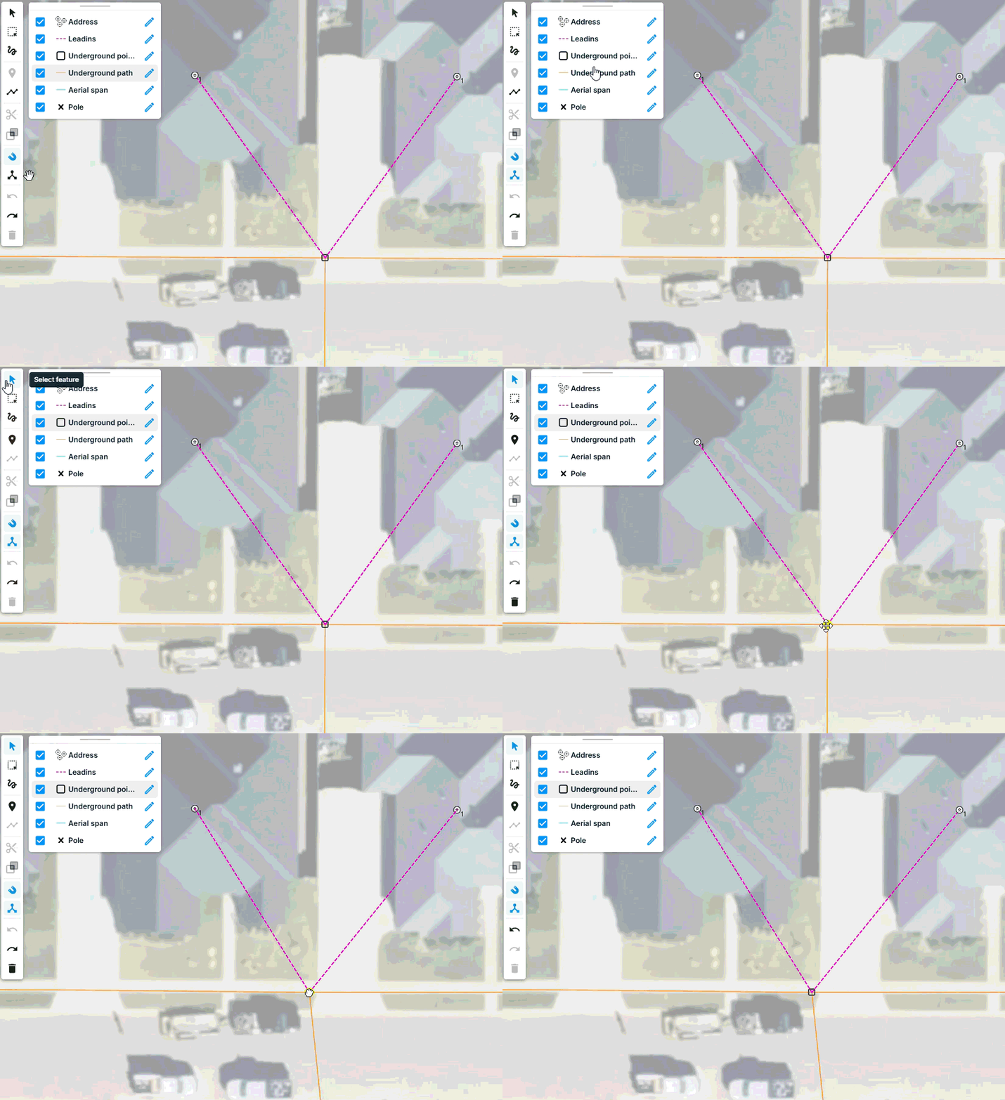
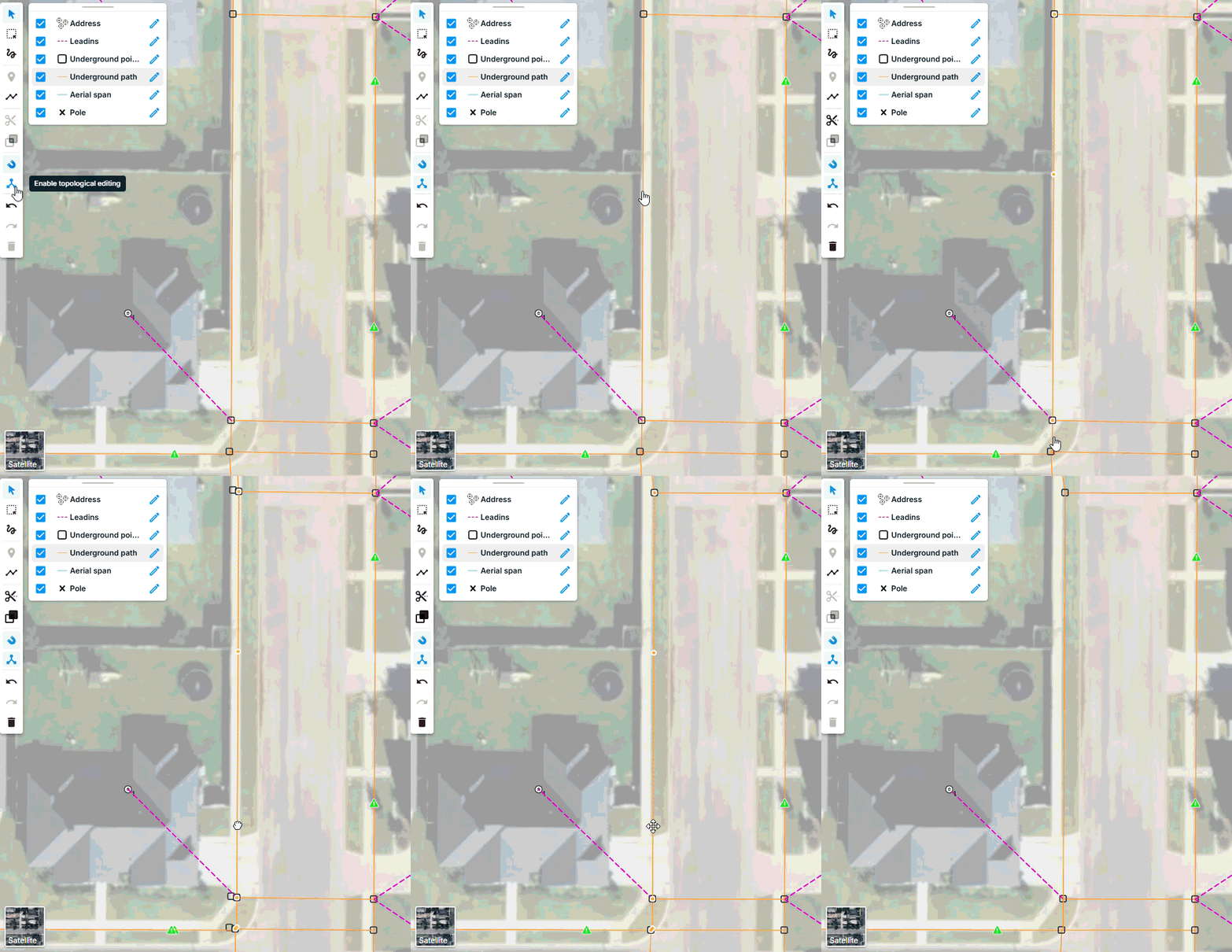
Tip: When editing underground path and points, be mindful of whether snapping and topological editing are enabled or disabled. It’s always recommended to use snapping. When snapping is on, an existing line turns blue when your new line will snap to it. Whether you want topological editing depends on the edit.
For example, if you want to move a point off a driveway, you probably want topologicallogical editing enabled so that all connected paths and leadins move with the point.
FOND helps you draw connected path
When you draw underground path and points, FOND does some of the connecting work for you:
- Points are added automatically at the ends of a path.
- A path is split automatically wherever you place a point on it.
This makes it much quicker to draw path that’s well connected.
Common edits
| Situation | What to do |
|---|---|
| Path crosses a railway, major road, or somewhere you can’t get permits | Delete those sections of path |
| You need path through a utility easement | Draw the path in, snapped to the generated network |
| A new development or private road has no path, because there’s no public data yet | Draw in the path, or add in the missing addresses, parcels, and street centerlines and generate again |
| A crossing or point is in a driveway |
Move it to a constructible location
|
| Too few crossings on a long block | Draw extra crossings, snapped to the path on both sides |
| The generated path is offset from the real utility easement by a few feet |
Delete and redraw the path, or select and move paths to the constructable location (use Shift + select for multiple paths)
|
Drawing a lot of new path? Consider first whether it would be quicker to clean up your parcels and streets and let FOND generate the underground path for you.
Checks as you edit
As you draw and edit, FOND checks your underground path and points as you work:
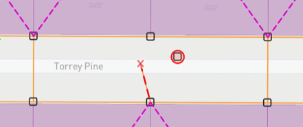
- A path turns red if one of its ends isn’t connected to a point.
- A point turns red if no path is connected to it.
Fix everything that’s red before you run your design.