Sourcing input data
To generate a design in FOND, you need some input data. There is a lot of open-source data available; here we’ll show you how to get hold of some of this and use it in FOND.
Area Select
You can access parcel, address and street data via the FOND Area Select feature, but only for certain countries. See Sourcing data with Area Select for the latest information on where Area Select is available.
For the rest of the world, you will need to source data externally. If your company doesn’t have any suitable data, read on.
If you are wondering what we mean by 'input data', may want to read What is input data?
BBBike
BBBike is a fantastic tool that allows you to download OpenStreetMap data in a format that can be consumed by FOND. Follow the process below to get the data into FOND.
To start, head to the BBBike website and choose the format you need (we recommend Shapefile)
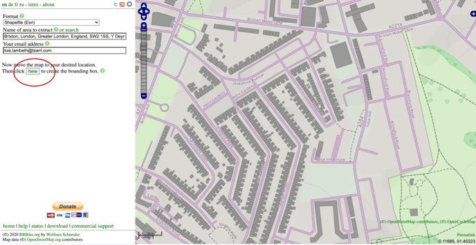
Then, find the area you are interested in, enter your email address, and click the ‘here’ button as shown below:
Then resize and reshape the polygon by clicking and dragging the orange circles:
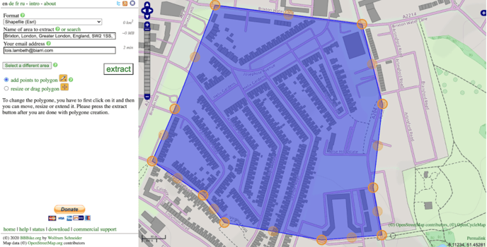
And then click ‘extract’.
You'll get an email with a link to a zip file containing the files. The files that are useful for FOND are:
- Buildings
- Roads
Underground path
You can upload the roads files into FOND as ‘Underground Path’:
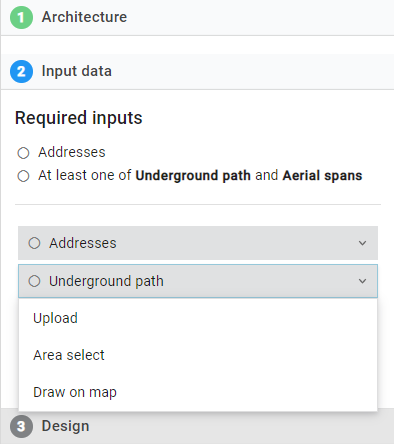
You can then review them, and if you want to edit, add roads or delete roads. You can do this by clicking the ‘Underground path’ → Draw on the map.
Addresses
You can use the building files in FOND as your ‘Addresses’, but you will need to convert them from polygons to points first. You can do this in QGIS.
Step 1: Open buildings.shp in QGIS.
.png?width=278&name=Sourcing%20data%20to%20use%20in%20FOND%20(4).png)
Step 2: Install a handy plugin in QGIS, realcentroids, to calculate the centroid of polygons. (You don’t need to use this plugin; there are other ways of doing this, but the plugin makes it easier.)
Go to Plugins → Manage and Install Plugins → type ‘realcentroid’ → Install plugin
.png?width=355&name=Sourcing%20data%20to%20use%20in%20FOND%20(5).png)
.png?width=600&name=Sourcing%20data%20to%20use%20in%20FOND%20(6).png)
Step 3: Then, select Plugins → realcentroid → Real centroids
.png?width=538&name=Sourcing%20data%20to%20use%20in%20FOND%20(7).png)
Step 4: Then click ‘Browse’ to create a filename for the building centroids
.png?width=406&name=Sourcing%20data%20to%20use%20in%20FOND%20(8).png)
Step 5: Type in a name for your file, and click ‘Save’:
.png?width=584&name=Sourcing%20data%20to%20use%20in%20FOND%20(9).png)
Step 6: You can now upload this file into FOND as ‘Addresses’:
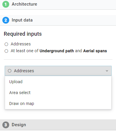
Step 7: We recommend that you check this data before using it. Read Inspecting input data for some tips.
Openaddresses
Openaddresses.io has address data for several countries and is worth looking into.
OpenStreetMap
The OpenStreetMap Project is a worldwide mapping effort, with more than a million contributing volunteers.
You can download data from this site in osm format, just click ‘Export’ → Export.
The data usually contains a buildings layer, which can be used as Address input to FOND, and a roads layer, which can be used as Underground path input to FOND.
However, to use this data in FOND, you will need to convert the file from osm to shp, kml or geojson format. You can find ways of doing this by searching online, or use a free tool such as QGIS.
Support for Open Source Projects
Free services like BBBike are incredibly valuable and Biarri Networks makes donations to help BBBike continue to be a valuable resource.
We also support the OSM Project by organizing company-wide ‘HOTathons’. HOT stands for Humanitarian OpenStreetMap Team; they are dedicated to humanitarian action and community development through open mapping.
Our ‘HOTathon’ events encourage our staff to spend half a day to contribute to this project. We’ve held three of these events since 2018 and most recently held one on 8 April 2020. This latest event targeted under-mapped communities around the world directly impacted by COVID-19. On 8th April, 18 of us contributed half a day each to map areas in South Africa. Check out the progress we made here:
